
Worldwide, many countries continue to experience an extended period of COVID-19 risks. There are no off-the-shelf solutions for managing such a complex crisis, in which measures to prevent transmission will have colossal economic and social costs. Countries are forced to confront hard choices of balancing the needs to save lives and to save livelihoods. The threat imposed by the COVID-19 pandemic therefore needs a systematic approach, in which the restrictions, states of lockdown and exit strategies all balance public health, societal, and economic needs. A balanced approach will also require a seamless integration of emergency response, easing of restrictions, and the post-COVID-19 long-term reconstruction phase.
Having leant from mega-disasters in the past, countries are adopting a range of innovative approaches such as indexing risk to transition step-by-step recovery from the COVID-19 pandemic.
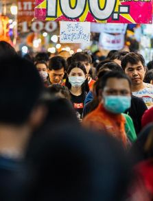
Risk zoning must inform the lifting of lockdown measures.
COVID-19 transmission occurs with the spread of contaminated droplets via physical contact and proximity. The sum of all of these contacts forms a large and dynamic network through which the COVID-19 virus spreads exponentially. These networks are the risk zones which need to be disconnected through effective social distancing measures. This ‘risk zoning’ approach is a key strategy for countries to suppress the transmission of virus. It was successfully implemented in several areas in China, which helped to reduce the spread between different areas and prevent the virus spreading throughout the territory.
Risk zoning strategies must also inform the lifting of lockdowns, through the creation of a graded reopening plan. In this technique, areas are divided into red, orange and green zones to represent high, medium and low levels of transmission risk. Respective governments define the geographical units used to identify the zones, and then assess the numbers of positive cases in each zone. Red zones are the risk hotspots, where containment areas must be earmarked for testing, isolation and quarantine measures. Within these zones, only key essential services are allowed, to ensure social distancing. Orange zones are those with limited number of cases in the past and no recent surge in positive cases. Here only restricted activities are allowed. Green zones are areas with no COVID-19 positive cases.
Risk zoning with red, orange and green zones is already being used around the world to inform the implementation and easing of lockdowns. For example, India, under a one and half month nation-wide lockdown, has adopted these risk zones as a key operational strategy to ease the restrictions of lockdown. For many countries, the time has come to design step-by-step exit strategies. For these countries, risk zoning can inform evidence-based, calibrated policy actions. The data science, especially geo-spatial tools, high resolution satellite, google and drone images, and big data analytics, help to define the zones, considering carefully their social and economic ties. The rules applying to each zone are clearly defined and risk informed. This emerging strategy builds public support, through the progressive enlargement of green zones, and offers a chance to rebuild post-COVID-19 social and economic interaction in a safe, efficient, and rapid way.
Risk matrices must be used to address the cascading impacts of COVID-19 and climate extremes.
Across Asia-Pacific, floods and drought often peak during the monsoon seasons starting from June, while tropical cyclones and heatwave seasons have already arrived. These climate extremes are likely to intersect with the COVID-19 pandemic. Whilst the risk transmission pathways of COVID-19 and extreme climate events are very different, many communities are exposed and vulnerable to both. For example, cyclone and flood shelters are designed to house hundreds and thousands of at-risk communities who are evacuated to save their lives. In some cases, these communities are also located in COVID-19 risk zones; they will not be able to practice social distancing and the necessary hygiene standards to prevent transmission. Furthermore, the number of mosquito-borne Dengue fever cases often greatly increases, during floods and cyclones. The interaction among climate emergencies and COVID-19 health care responses could magnify negative impacts in some countries. Implementation of response strategies and pre-emptive actions that factor in the current pandemic are needed to protect areas exposed to extreme climate events from becoming new epicenters of the pandemic.
COVID-19 response and recovery must be risk informed.
The Sendai Framework for Disaster Risk Reduction 2015-2030 recognizes the links between epidemics and disasters. Its operationalization requires innovative solutions, such as indexing risk and creating risk matrices in response to the COVID-19 pandemic and its intersection with extreme climate events. Therefore, ESCAP’s initiative to develop a guidebook on risk analytics for intelligent crisis management solutions is an important step forward. Supported through the Asia-Pacific Disaster Resilience Network (APDRN), such solutions are derived from risk analytics and state of the art multi-model ensemble techniques that calibrate early warning for targeted early actions to address crises that originate from multiple origins. The guidebook will be complemented by capacity development activities.