  • UN ESCAP - Home
  •  
  • UN ESCAP - Home
  •  
  • UN ESCAP - Decade of Action
  •  
  • RISK AND RESILIENCE PORTAL

    Bridging the science policy gap for informed action

  • Log in
  • Home
  • Risk Atlas expand_more
  • Country Tools & Applications expand_more
  • Regional cooperation expand_more
  • E-learning & Knowledge expand_more
Home

expand_more Risk Atlas

    expand_more Hazard Hotspots

      Climate-related and biological multi-hazard Drought Flood Heatwave Cyclone Earthquake and Tsunami

    expand_more Economic Impact

      Regional Economic Impact East and North-East Asia North and Central Asia Pacific South-East Asia South and South-West Asia Pacific Small Island Developing States

    expand_more Adaptation costs and priorities

      Regional Overview East and North-East Asia North and Central Asia Pacific South-East Asia South and South-West Asia Pacific Small Island Developing States

expand_more Country Tools & Applications

    expand_more Country profiles

      Afghanistan American Samoa Armenia Australia Azerbaijan Bangladesh Bhutan Brunei Darussalam Cambodia China Cook Islands D.P.R. Korea Fiji French Polynesia Georgia Guam India Indonesia Iran (Islamic Republic. of) Japan Kazakhstan Kiribati Kyrgyzstan Lao P.D.R. Malaysia Maldives Marshall Islands Micronesia (F.S) Mongolia Myanmar Naoero Nepal New Caledonia New Zealand Niue Northern Mariana Islands Pakistan Palau Papua New Guinea Philippines Republic of Korea Russian Federation Samoa Singapore Solomon Islands Sri Lanka Tajikistan Thailand Timor-Leste Tonga Türkiye Turkmenistan Tuvalu Uzbekistan Vanuatu Viet Nam
    Decision support systems Risk Atlas Resilience SDG Tracker for disaster and climate resilience

expand_more Regional cooperation

    The Aral Sea catastrophe - Storyboard Shared Borders, Shared Resilience Early Warnings for All

expand_more E-learning & Knowledge

    expand_more E-learning tools

      IBF Course DiDRR Part 1 : Basic DiDRR Part 2 : Advanced
    Knowledge products
CARA Loading coastal story…
Skip to content

CARA Coastal Storyboard · ESCAP

From Coastal Risk to Resilience in Asia and the Pacific

Explore how hazards, data, and adaptation tools shape informed coastal planning and resilience across Asia and the Pacific.

Coastal hazards Data for resilience ESCAP project Adaptation planning

Leila@UNESCAP

CS-001 · Coastal Hazards in Asia-Pacific

A convergence of tsunamis, climate induced, and ocean-related hazards

Coastal countries in Asia-Pacific face a convergence of tsunamis, climate induced, and other ocean-related hazards that threaten millions of people, critical infrastructure, and fragile ecosystems.

68 million
People potentially exposed
to a low-probability, high-impact tsunami
US$ 2.35 trillion
In buildings and property could be damaged by
low-probability, high-impact tsunami
78,145 km²
Mangroves facing ocean warming
by 2050 under current emissions trends
57,149 km²
Coral reefs potentially facing severe damage or die-off
by 2050 under current emissions trends

CS-002 · Historic Record

Asia-Pacific experiences some of the world’s most frequent and intense coastal disasters

Disasters that changed the way we understand coastal hazards show how tsunami, cyclone, coastal flooding, coral bleaching, and storm surge reshape preparedness across the region.

Skip event markers

Use Ctrl + Scroll to zoom the map

1 m 0.51 m 0.02 m
1992
2026

CS-003 · Historic Disasters

Disasters that changed how we understand coastal hazards

Some disasters do more than leave a lasting impact on communities. They also change policies, institutions and approaches to preparedness. Explore how two landmark disasters transformed coastal disaster risk management in the region.

Indian Ocean Tsunami

On 26 December 2004, communities across the Indian Ocean faced a tsunami that changed lives in an instant. The disaster became a catalyst for stronger cooperation, better preparedness, and a shared commitment to protecting people from future coastal hazards.

Odisha Super Cyclone

When the Odisha Super Cyclone struck India's east coast in 1999, its impacts were felt far beyond the shoreline. The event triggered a fundamental shift in disaster preparedness and risk management.

1 / 7

After the Wave: How 2004 Changed Tsunami Preparedness

The Indian Ocean tsunami revealed a critical gap in coastal risk management. Two decades of regional cooperation have transformed how tsunamis are detected, communicated and prepared for. Yet expanding coastal exposure means that preparedness must continue to evolve.

What happened in 2004

On 26 December 2004, a magnitude 9.1 earthquake off northern Sumatra generated a tsunami that travelled across the Indian Ocean. More than 230,000 lives were lost, 1.7 million people displaced, entire coastal communities wiped away and the economic cost across 14 countries stood over $10 billion.

In many affected locations, people did not receive an official warning. Tsunami risk was not widely understood, evacuation procedures were limited, and the Indian Ocean did not yet have a coordinated regional tsunami warning and mitigation system.

The scale of the disaster demonstrated that a hazard originating in one location could affect distant countries within hours. Tsunami risk could not be managed by one community or country acting alone.

Watch on YouTube

The tsunami was the hazard. Exposure and vulnerability shaped the disaster.

Tsunami hazard
How far, fast and high the water may travel.
Exposure
People, buildings, infrastructure and livelihoods located in inundation zones.
Vulnerability
Conditions that make it difficult to withstand the impact or evacuate in time.
Preparedness
The systems, knowledge and capacity needed to act before the waves arrive.

When exposure and vulnerability increase faster than preparedness, disaster risk expands.

What would the same hazard meet today?

The coastline has changed since 2004.

Today, many Indian Ocean coastlines contain more people, buildings, transport networks, tourism facilities and economic assets than they did in 2004. New development can bring opportunity, but it can also place more people and assets within tsunami inundation zones. Informal settlements, seasonal tourism, ageing infrastructure and dependence on coastal livelihoods can add further layers of vulnerability.

A tsunami of comparable physical characteristics would therefore not simply reproduce the impacts of 2004. It would interact with a different social, economic and built environment.

Map showing population exposed to earthquake-induced tsunami and multi-hazard hotspots across Asia-Pacific countries, from low to very high hazard levels
Population exposed to earthquake-induced tsunami (500-year return period) and multi-hazard hotspots within the tsunami inundation zone.

What changed after 2004

2004 exposed the gaps

  1. 2005

    ESCAP Trust Fund for Tsunami, Disaster and Climate Preparedness is established

    • Created to strengthen regional cooperation and support tsunami early warning systems through a multi-hazard approach.
    • Provides assistance to countries with high disaster risk and limited preparedness capacities.
  2. 2005

    UNESCO-IOC establishes the Indian Ocean Tsunami Warning and Mitigation System (IOTWMS)

    • Creation of a coordinated regional tsunami warning system for the Indian Ocean.
    • Establishment of tsunami service providers, monitoring networks, warning protocols, and preparedness programs.
    • Promotion of risk assessment, public education, and community preparedness.
  3. 2005–2006

    Regional Monitoring Infrastructure Deployed

    • Seismic stations, sea-level gauges, tsunami detection systems and communications networks were established across the Indian Ocean, enabling rapid tsunami detection and warning dissemination. These systems formed the backbone of the Indian Ocean Tsunami Warning System (IOTWS)
  4. 2005–2010

    National Tsunami Warning Centres Established

    • Countries across the Indian Ocean established and strengthened national tsunami warning centres, including INCOIS (India), BMKG (Indonesia), and Australia's national warning services. These centres became the primary link between regional warning systems and at-risk communities.
  5. 2007–2012

    Community Preparedness Expanded

    • Tsunami hazard maps developed.
    • Evacuation routes and signage installed.
    • Public awareness and school education programmes launched.
    • Warning systems expanded (sirens, SMS, radio, TV).
    • Regular tsunami drills and exercises conducted.
  6. 2012

    Indian Ocean Tsunami Information Centre (IOTIC) is established

    • Supports regional training and capacity-building for tsunami preparedness.
    • Develops public awareness and education programmes to improve understanding of tsunami risks.
    • Helps countries strengthen emergency response planning and tsunami risk reduction efforts.
    • Facilitates the sharing of knowledge, good practices, and preparedness resources across the Indian Ocean region.
  7. 2013

    Regional Warning System Becomes Operational

    • The Indian Ocean Tsunami Warning and Mitigation System (IOTWMS) became fully operational after years of regional cooperation and development.
    • Australia, India, and Indonesia began providing regional tsunami warning services for the Indian Ocean basin.
    • Countries gained access to coordinated tsunami monitoring, forecasting, and warning information.
    • Standardized warning procedures improved communication and coordination across the region.
    • Regional warning centres and national agencies became connected through a common tsunami warning architecture.
  8. 2022

    UNESCO-IOC Tsunami Ready Programme Launched Globally

    • Global community recognition programme for tsunami preparedness established by UNESCO-IOC.
    • Communities are assessed against internationally recognized 12 preparedness indicators.
    • Promotes evacuation planning, public awareness, warning dissemination, and regular exercises.
    • Supports the goal of making all tsunami-risk communities resilient and prepared by 2030.
  9. 2025

    Regional Cooperation Strengthened Through IOWave25

    • The Indian Ocean Tsunami Warning and Mitigation System (IOTWMS) continued to strengthen cooperation among Member States on tsunami risk assessment, early warning, and preparedness.
    • The IOWave25 regional exercise brought together 23 Member States and more than 400 representatives from tsunami warning centres, disaster management agencies, emergency services, critical infrastructure operators, and the media.
    • The exercise tested rapid detection, coordinated decision-making, and timely warning dissemination across the region.

Why does regional cooperation matter?

The ocean connects the risk. Cooperation connects the response. Tsunamis cross national boundaries. Monitoring data from one country may help another country assess its threat. Regional service providers, national warning centres, disaster management agencies and local authorities therefore form parts of one interconnected system.

Turning regional commitment into practical preparedness

The ESCAP Trust Fund for Tsunami, Disaster and Climate Preparedness (established in 2005) strengthens tsunami early warning through a multi-hazard approach and supports an effective regional preparedness mechanism in the Indian Ocean and South-East Asia. In 2010, the Trust Fund was broadened to encompass disaster and climate preparedness, and in 2015, it expanded its geographic scope to include SIDS in the Southwest Pacific.

The Trust Fund has supported innovative pilot initiatives, helped scale successful warning systems and strengthened cooperation among high-risk, lower-capacity countries. Its work connects regional science and technology with national institutions and inclusive local action.

Image

Learn more

Lessons learned

Rare hazards require continuous preparation

  • Major disasters may occur infrequently, but preparedness systems, exercises and response plans must be maintained between events.

Early warning is more than detection

  • Detecting a tsunami is only the first step. Warnings must be timely, understandable and actionable for communities at risk.

Preparedness must reach communities

  • Hazard maps, evacuation routes, public education and drills are as important as monitoring technology.

National and local capacity matters

  • Countries need dedicated warning centres, clear emergency procedures and trained institutions capable of acting rapidly.

Regional cooperation saves lives

  • Tsunamis cross borders. Effective preparedness depends on shared monitoring networks, data exchange, common standards and coordinated warning services.

Resilience requires inclusion

  • Preparedness efforts should be accessible to all, including people with disabilities, older persons, visitors, and communities with limited access to technology.

1 / 7

Odisha 1999: The Cyclone That Transformed Coastal Preparedness

How a devastating cyclone transformed the understanding of coastal risk and demonstrated the life-saving value of early warning, evacuation and community action.

Odisha's 1999 Super Cyclone was one of the most severe coastal disasters in India's recent history. It caused widespread loss of life, damaged homes, infrastructure, livelihoods and ecosystems, and exposed critical gaps in preparedness.

It also changed the way coastal risk is understood. Odisha's experience shows that disaster risk is shaped not only by the strength of a cyclone, but also by exposure, vulnerability, warning systems, shelters, local governance and community action.

Satellite image of the 1999 Super Cyclone over the Bay of Bengal, its eye on the Odisha coast
The Super Cyclone making landfall on the Odisha coast, 29 October 1999 (METEOSAT-5 visible image). Credit: Joint Typhoon Warning Center, public domain, via Wikimedia Commons.

Odisha’s risk factors

Coastal exposure

  • The Bay of Bengal is one of the most active cyclone-prone basins.
  • Odisha has 574.71 km coastline along the Bay of Bengal.
  • Low-lying settlements exposed to cyclones, storm surge and saline inundation.
  • Homes and essential infrastructure located close to the shore.

River delta and floods

  • Four major river systems crossed the coastal and delta landscape.
  • The Mahanadi catchment covered approximately 42 % of the state.
  • Cyclone rainfall, river flooding and storm surge could occur together.

People and livelihoods

  • Approximately 52 % of the population lived within 25 % of the state's coastal area.
  • Many households depended on agriculture, fisheries and livestock.
  • Fragile housing and limited financial resources increased vulnerability.

Communication barriers

  • Odisha has many languages and dialects, which makes inclusive early warning and last-mile communication important.
  • Remote settlements are difficult to reach.
  • Electricity and telecommunications could fail during severe weather.

The cyclone: 29 October 1999

Best track of the 1999 Super Cyclone from 25 October to 3 November: it crossed the Bay of Bengal, made landfall near Paradip on 29 October and stalled over Odisha for about two days. Track: IBTrACS (NOAA NCEI); basemap: UN Maps.
Before landfall
A powerful system developed over the Bay of Bengal.
29 October 1999
The Super Cyclone made landfall on the Odisha coast.
Extreme wind and rainfall
Wind speeds exceeded 250 km/h, followed by more than 200 mm of rainfall over three consecutive days.
Storm surge and flooding
Coastal areas were severely inundated, with widespread damage to settlements, agriculture and infrastructure.

Impact

9 885 lives lost
13 million people affected
1.66 million houses damaged
12 000 km of rural roads damaged
3 435 high schools damaged
25 000 ha of mangroves damaged
9 085 fishing boats damaged
9 million trees uprooted
1.35 million ha of paddy damaged

What made it a disaster?

The cyclone was extreme. But the scale of loss was shaped by where people lived, how warnings reached them, the strength of shelters and roads, and the ability of communities to act before landfall.

UNDRR infographic: the different dimensions of disaster risk, showing hazard, exposure and vulnerability combining to produce disaster risk

From loss to learning: what changed?

1999 exposed the gaps

  1. Dedicated institutions

    • December 1999 – the Odisha State Disaster Management Authority was established.
    • 2001 – the Odisha Disaster Rapid Action Force was formed. 20 ODRAF units were formed, supported by specialized equipment and facilities.
  2. Risk-informed planning

    • Approximately 20,000 village disaster management plans were prepared, helping communities identify local hazards, vulnerable people, available resources, evacuation arrangements and responsibilities before an emergency occurs.
    • OSDMA introduced multi-hazard risk and vulnerability analysis through its geographic information system capacity. Flood atlases and long-term rainfall analyses strengthened understanding of where risk is concentrated.
    • Automated monitoring was extended across 314 blocks and 191 highly vulnerable Gram Panchayats (village councils) through weather, rainfall and water-level instruments.
  3. Early warning and last-mile communication

    • 122 alert-siren towers were installed within 3 km of the coastline.
    • SMS alerts became part of public warning dissemination.
    • The State Emergency Operation Centre was integrated with the 112 Emergency Response Support System and was connected with District Emergency Operation Centres in all 30 districts.
  4. Evacuation routes and cyclone shelters

    • Odisha developed 911 multipurpose cyclone and flood shelters across the state.
    • 58.23 km of highly vulnerable saline embankments were strengthened in Puri, Bhadrak, Kendrapara and Balasore.
    • A 675-metre geosynthetic coastal wall in Kendrapara was designed to reduce erosion and help protect livelihoods in approximately 35 villages.
    • The Kasafala Multipurpose Cyclone Shelter in Balasore serves as a community facility between emergencies, maintains a ₹10.56 lakh preparedness fund, and holds an inclusive annual evacuation drill involving local youth and vulnerable groups.
  5. Local leadership and trained volunteers

    • Odisha developed a community-led disaster management system for villages without dedicated cyclone shelters. 10,000 community volunteers were trained to support local preparedness, and an additional 6,000 received specialized training for drowning rescue.
    • In Puri district, 102 women's self-help groups with 1,310 members established a locally funded disaster relief mechanism that provides non-repayable, needs-based assistance to anyone in the Gram Panchayat.
  6. Regular drills and continuous learning

    • Disaster management was included in the curriculum of the State Secondary Education Board.
    • Special awareness programmes were introduced for hazards including lightning and snakebite.
    • Tsunami preparedness activities were undertaken in 381 coastal villages located within 1.5 km of the coast.
    • 26 villages in six coastal districts were declared Tsunami Ready by India's National Tsunami Ready Board and recognized by UNESCO.

From reactive relief to anticipatory, people-centred preparedness

Lessons learned

Before impact

Move from Managing Disasters to Managing Risk

  • Preparedness must begin before a hazard occurs.
  • Risk assessment, prevention, mitigation and contingency planning can reduce impacts before landfall.
  • Hazard, exposure and vulnerability information should guide development and investment decisions.

Institutionalize Disaster Risk Reduction

  • Preparedness requires dedicated institutions, clear responsibilities and sustained resources.
  • Coordination must connect state, district and local authorities.
  • Disaster risk reduction should be part of everyday governance and development planning, not only emergency response.

Turn Warnings into Anticipatory Actions

  • Forecasts must trigger timely decisions, including opening shelters, mobilizing responders and beginning evacuation.
  • Warnings must reach people in understandable, accessible and actionable forms.
  • Alerts must be connected to evacuation routes, transport assistance and safe shelters.

Sustaining resilience

Include Communities

  • Local authorities, community organizations and trained volunteers should participate in planning, warning dissemination, evacuation and shelter management.
  • Preparedness should address barriers faced by older persons, children, persons with disabilities, people with limited mobility, low-income households and linguistically diverse communities.
  • Local knowledge helps identify exposed locations, trusted communication channels and people who may require additional assistance.

Build Connected Systems

  • Shelters, evacuation roads, communications, health facilities and water systems should remain functional during and after disasters.
  • Cyclone planning should also consider storm surge, river flooding, coastal erosion and saline intrusion.
  • Institutions, infrastructure, technology and community action are most effective when designed as one connected system.

Practise, Maintain, Improve

  • Regular drills test warning chains, evacuation routes, shelter operations and institutional responsibilities.
  • Warning systems, shelters, plans and skills require maintenance and continued investment.
  • Lessons from exercises and real events should be used to update procedures.
  • Odisha's experience can inform other cyclone-prone areas, but solutions must be adapted to local risks, institutions and capacities.

Odisha shows that an extreme cyclone does not have to produce the same human consequences every time. When risk information, institutions, early warning, infrastructure and community action work together, preparedness can change outcomes.

CS-004 · Climate Projections

Asia-Pacific Coastal Risks and Climate Exposure Trends

Explore how sea surface temperature, thermal stress and coastal flooding could develop across the region, and where population, mangroves and coral reefs may face increasing exposure. Compare trends at regional, subregional and country levels to identify emerging hotspots.

CS-005 · Coastal Values

CS-008 · Marine Heatwave

Heat impacts are cascading across systems and disproportionately affect the vulnerable

Marine heat risk is now formally recognized as a regional priority by the ESCAP for disaster risk reduction and early warning systems — ESCAP/CDR(9)/5

Marine heatwave Cyclone Change Coastal Communities Ocean to Glacier Fisheries & Coral bleaching

Cyclone change

Marine heatwaves increase ocean heat content, intensifying tropical cyclones and amplifying coastal damage and flooding.

From ocean to glacier

Marine heatwaves alter ocean temperature and circulation, accelerating ice melt and influencing sea-level rise and polar/coastal systems.

Fisheries & Coral bleaching

Marine heatwaves cause coral bleaching and ecosystem disruption, leading to declines in fish stocks and cascading impacts on food security and livelihoods.

Coastal communities

Marine heatwaves translate into economic losses, food insecurity, and heightened risk for vulnerable coastal populations.

CS-009 · Risk to Resilience

From understanding risk to building resilience

Understanding risk is only the starting point. Building resilient coasts requires countries to connect global commitments with local knowledge and turn integrated analysis of hazards, exposure and vulnerability into informed decisions and coordinated action. Moving from understanding coastal risk to reducing it requires regional analysis to be translated into decision-ready information, supported by practical planning tools and the capacity to anticipate risks, prepare for impacts and plan for adaptation.

CS-010 · Global Frameworks

Connecting global ambitions with regional coastal actions

Global and regional initiatives are moving toward integrated, anticipatory, inclusive, and data-driven resilience. The ESCAP Risk and Resilience Portal helps translate these shared ambitions into practical regional and country-level knowledge for disaster preparedness, climate adaptation, ecosystem protection and sustainable development.
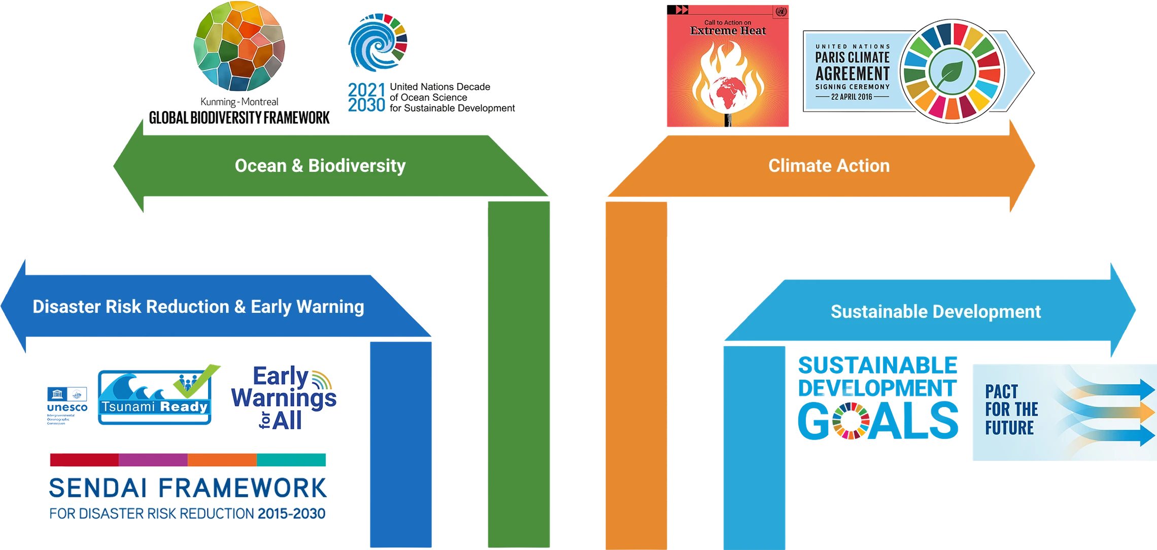
Four framework groups feed the ESCAP Risk and Resilience Portal: Disaster Risk Reduction and Early Warning (Sendai Framework, UNESCO IOC Tsunami Ready, Early Warnings for All), Ocean and Biodiversity (Kunming-Montreal Global Biodiversity Framework, UN Decade of Ocean Science), Climate Action (UN Call to Action on Extreme Heat, Paris Climate Agreement) and Sustainable Development (Sustainable Development Goals, Pact for the Future).
ESCAP
Risk & Resilience Portal

Strengthens disaster risk knowledge and early warning; supports risk-informed early warning and preparedness; builds community-level capacity for tsunami-prone coasts.

Contributes to coastal resilience and ocean-risk knowledge; uses coastal and marine ecosystems as part of adaptation and disaster risk reduction.

Supports climate adaptation and resilience commitments under NDCs; supports resilience to compounding heat risk in coastal and urban areas.

Anchors resilience work within the broader sustainable development framework.

CS-013 · Tools and Initiatives

From data to coastal resilience decisions

Turning commitments into practical decisions requires data that helps countries understand where risks are concentrated, who and what is exposed, and which actions can reduce future losses. The ESCAP Risk and Resilience Portal brings together complementary tools that help users move from understanding hazards and exposure to identifying hotspots and informing action.

01

Understand hazards

Integrate high-resolution data to characterize flooding, storm surge, erosion, sea-level rise, and other coastal hazards.

  • Map areas potentially affected by storm surge or coastal inundation
  • Examine shoreline exposure to sea-level rise
  • Compare multiple coastal hazards affecting the same location
  • Use selected coastal risk layers available at approximately 30 m to 1 km resolution, depending on the dataset
02

Identify exposure

Overlay coastal hazard layers with information on population, settlements, infrastructure, economic activity, and ecosystems.

  • Estimate populations located within a coastal flood or tsunami zone
  • Identify exposed roads, schools, hospitals, ports, and settlements
  • Locate coastal ecosystems and livelihoods potentially affected
03

Locate risk hotspots

Reveal where risks are concentrated, which groups are most vulnerable, and where intervention is most urgent.

  • Identify where severe hazards overlap with dense populations
  • Locate vulnerable communities near critical infrastructure
  • Compare coastal areas facing multiple or compounding hazards
  • Prioritize locations for detailed assessment and intervention
04

Inform action

Translate coastal risk information into practical choices about warning coverage, preparedness, land use, infrastructure, adaptation and resilience.

  • Refine warning zones and evacuation routes
  • Identify communities requiring targeted warning communication
  • Prioritize resilient infrastructure or ecosystem restoration
  • Direct adaptation finance toward the highest-risk locations

ClimaCoast

Multi-Hazard Vulnerability Coastal Tool — integrates tsunami, sea-level rise, storm surge, and other ocean-related hazards with exposure and vulnerability layers to pinpoint shoreline hotspots and guide actionable resilience planning.

Developed under the CARA funded project Learn more

ClimaWise

AI-powered tool for climate adaptation planning with global case studies and tailored recommendations based on unique risk profiles.

Developed under the CARA funded project Learn more

IBF Plugin

Automated impact-based forecasting for planning windows at seasonal scale, translating hazard information into clear insights on impacts to people, infrastructure, and services.

Developed under the CARA funded project Learn more

Maldives DSS page

A tailored, risk-informed decision support system using national data to assess climate risks, sectoral impacts, and vulnerable populations.

Updated with heat data under the project Learn more

ESCAP Trust Fund for Tsunami, Disaster and Climate Preparedness

A regional initiative established after the 2004 Indian Ocean tsunami to strengthen multi-hazard early warning systems, disaster preparedness, and climate resilience across Asia-Pacific and Small Island Developing States.

Learn more

SATGPT

An innovative solution integrating LLMs, cloud computing platforms, and Earth observation data for flood hotspot mapping.

Learn more

CS-015 · Multi-hazard Coastal Analysis and Adaptation Project

Connecting Science and Policy for Coastal Resilience

Building coastal resilience requires different parts of the risk and decision-making process to work together. When data, analysis and decision support are not fully connected, translating scientific knowledge into policy and action can be challenging. The Risk and Resilience Portal: Multi-Hazard Coastal Analysis and Adaptation Project helps complete the picture by strengthening the connections between risk knowledge, decision-making and practical action.

Drag each piece into its matching gap, or click a piece and it will slide into place.

Knowledge

Operationalize a regional, integrated approach to identify and visualize multi‑hazard coastal risk hotspots.

Decisions

Translate regional coastal risk analytics into decision‑ready tools, country‑level risk assessments, and visual storyboards that support early warning, preparedness, and adaptation planning.

Action

Enhance national and regional capacity to apply multi‑hazard coastal risk information through training, stakeholder engagement, and regional learning platforms.

CS-017 · Country Applications

Bringing coastal risk analysis into country context

In the Maldives and Sri Lanka, regional methods are applied to distinct national and local contexts. Explore how coastal hazards intersect with exposed populations, ecosystems and economic sectors, and how partnerships, workshops and tailored decision support help turn regional knowledge into country action.

Maldives

Different Islands, Different Risks

Flood risk varies across the Maldives. Some islands have high numbers of exposed people and assets, while others have a large share of their land within the flood zone.

Different Islands, Different Risks

Hulhumalé, Malé, Hulhulé, Hithadhoo, Gan, Thinadhoo and Feydhoo repeatedly appear as hotspots because they have high concentrations of people, roads, buildings and essential services.

Other islands face a different challenge. Even where the number of exposed people is lower, flooding may affect most of the available land. This can leave limited safe space for evacuation, temporary shelter, continued services or rebuilding.

~38,400 people
potentially exposed to a low-probability, high-severity flood under projected 2050 sea levels
76% of land
potentially exposed on Raiymandhoo and Manafaru
over 70% of land
potentially exposed on Thakandhoo

Tsunami Risk

A severe tsunami could affect entire island communities, not only areas close to the shoreline.

Tsunami Exposure Reaches Beyond the Shoreline

In some places, the modelled inundation zone covers a large share of the populated area.

Male' City has by far the largest absolute exposed population, with approximately 191,969 people located inside the modelled tsunami inundation zone.

Several other atolls also show high exposure as a proportion of their population: 67% of Seenu Atoll's population and 55% of Thaa Atoll's population are potentially exposed to tsunami.

83.7% of Malé City's
population is within the modelled tsunami inundation zone

Reefs Under Stress

Ocean warming could place almost all coral reefs under severe heat stress, threatening nature, livelihoods and coastal protection.

Coral Reefs Face a Rapid Shift to Heat Stress

Coral reefs are essential to the Maldives. They support fisheries and tourism, provide habitats for marine life, and help protect islands by reducing wave energy.

The analysis shows a major shift from historically limited heat stress to widespread severe stress in the future. Damage to reefs would therefore be more than an environmental loss. It could also affect food security, jobs, tourism income and natural protection from waves.

Under the high-emissions SSP5-8.5 pathway, Maldives reefs transition from no high-stress exposure historically to 100% of mapped reef area experiencing moderate-to-high thermal stress by mid-century, including almost 40% under high stress.

Kulhudhuffushi

ClimaCoast's assessment of Kulhudhuffushi highlights areas exposed to coastal flooding and vulnerable groups, broadly aligning with local reports and providing a useful starting point for preparedness and adaptation.

Kulhudhuffushi: Testing the Data Locally

Kulhudhuffushi brings the national story down to city scale. Local reports already identify flooding, storm surge and heat as important concerns for the island.

The comparison found a clear overlap: both local information and ClimaCoast highlight the low-lying northeastern part of Kulhudhuffushi as more exposed to coastal flooding. The tool also broadly reflects the island's built-up structure and the distribution of vulnerable groups, making it a useful starting point for local conversations on preparedness and adaptation.

Regional data becomes more powerful when it is checked against local reality.

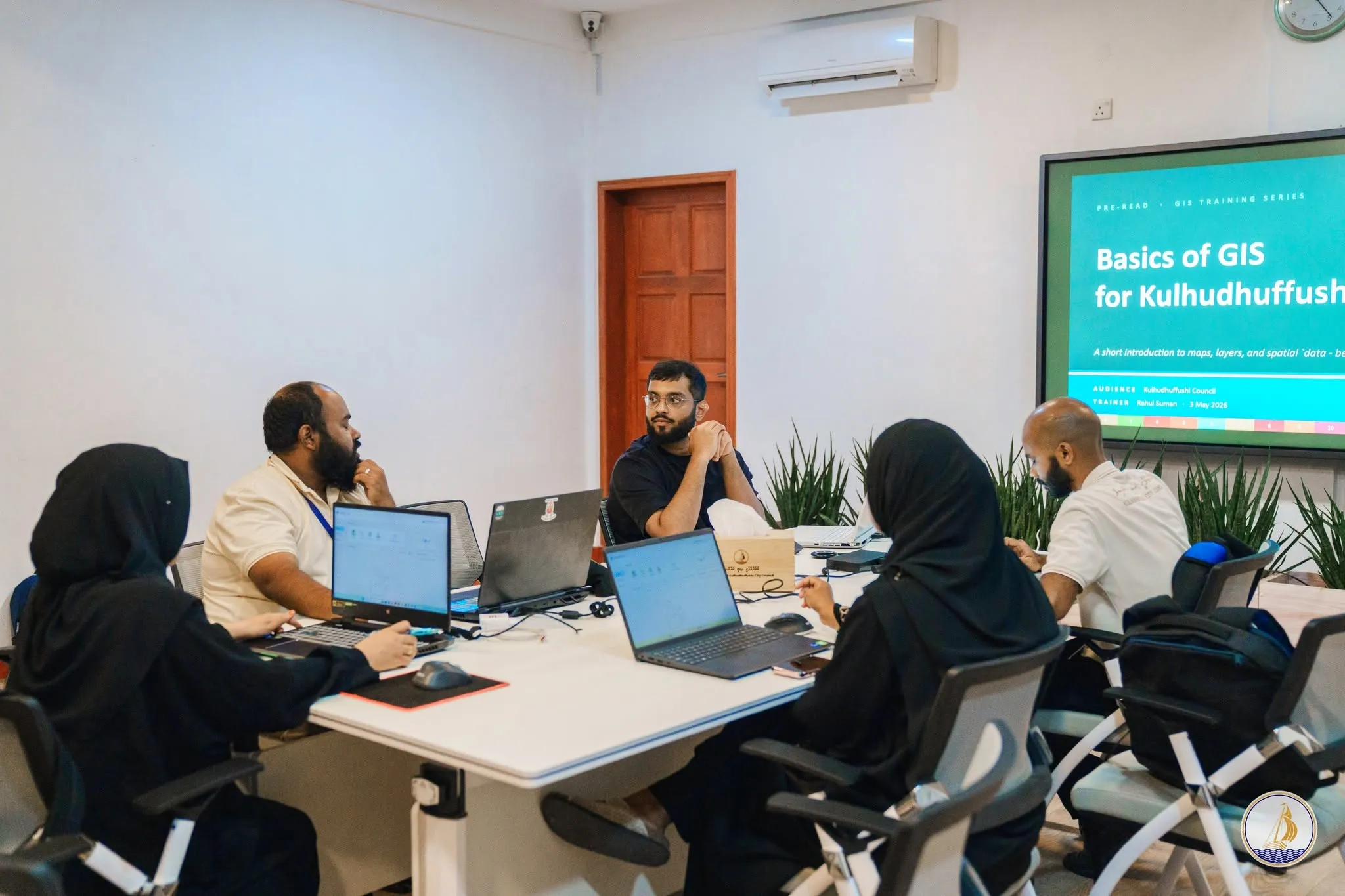
Workshop

Risk data is most useful when it reflects local knowledge and can be used by the people responsible for planning.

The workshop brought together national agencies, local councils, technical experts and community representatives. Participants reviewed the risk information, identified local priorities and learned how to use the tools for future assessments.

National Engagement Turned Data Into Action

  • Downscaled climate variables for island-level decision-making
  • Integrated Multi-Hazard Analysis to identify cascading risks
  • Collaborative Priority Setting across government and communities
  • Enhanced National Capacity through practical risk assessment tools
National Disaster Management Authority (NDMA) Maldives Meteorological Service Kulhudhuffushi City Council
Maldives workshop photo 1

Sri Lanka

Risks Are Connected

Coastal hazards can affect communities in several ways at once, damaging homes and farmland while disrupting roads and essential services.

Sri Lanka faces interconnected coastal and climate risks

Sri Lanka faces interconnected coastal risks, including flooding, tsunamis, shoreline erosion and increasing heat stress on coral reefs.

The effects extend far beyond the shoreline. Coastal flooding can damage farmland and threaten rural livelihoods. Even a short flooded section of road can interrupt access to schools, hospitals, markets and emergency services.

Tsunamis can also affect entire coastal systems. Alongside homes and settlements, schools, health facilities, roads and informal settlements fall within the modelled inundation zone. Exposure is particularly concentrated along the eastern and northern coasts, with additional areas at risk in the south-western urban corridor.

4,700 km of roads
within the modelled inundation tsunami zone
2.86 km² of farmland in Batticaloa
could be at risk of coastal flooding by 2050 as sea levels rise under a high-emissions future, based on a severe flood with a 4% chance of occurring over a 10-year period.
211 education facilities & 95 health facilities
potentially exposed to tsunami inundation

Eastern Hotspots

Coastal flood risk is not evenly distributed. Ampara and Batticaloa repeatedly stand out across population, land, roads and farmland.

Coastal Risk Clusters Along the East Coast

Coastal flooding affects different parts of Sri Lanka in different ways.

Batticaloa facing the largest exposure at 3,224 people, followed by Ampara (2,508) and Galle (1,643) under the 2050 sea-level and 250-year flood scenario.

Other districts, including Galle, Gampaha, Puttalam, Jaffna and Colombo, also face coastal flooding, with particular communities, roads and areas of land exposed.

By 2050, around 11,800 people could be exposed to coastal flooding reaching 0.5 metres or more as sea levels rise under a high-emissions future. The estimate is based on a severe flood with a 4% chance of occurring over a 10-year period.

Older persons are the fastest-growing at-risk group, with flood exposure increasing 22.9% by 2030, compared with 4.0% for the overall population.

Access to Health Care

A hospital may remain outside the flood zone but become difficult to reach when surrounding roads are disrupted.

Health Access Depends on Roads, Not Just Hospitals

During a flood, reaching health care can become difficult even when the hospital itself remains safe. Flooded or closed roads can delay ambulances, lengthen journeys and leave some communities temporarily cut off from essential care.

Most flood-prone communities have a hospital outside the flood zone within reach, but the journey may be several kilometres long. Under projected 2050 sea levels, around 140 high-risk hotspots could face flooding with no reachable hospital in an emergency.

Preparing for these disruptions means identifying roads that could become blocked, planning alternative ambulance routes and considering where temporary health services may be needed.

Changing Coasts

Ocean warming is increasing pressure on coral reefs, while parts of the western shoreline are already experiencing erosion.

Reefs and Shorelines Are Changing Risk Frontiers

Sri Lanka's reefs and shorelines support fisheries, tourism and coastal livelihoods. They also provide natural protection by reducing wave energy and helping to stabilize the coast.

Under a high-emissions future, all mapped reef areas could experience high or very high severe heat stress by the end of the century. This could weaken marine ecosystems and reduce the benefits that healthy reefs provide to coastal communities.

Under the high-emissions SSP5-8.5 scenario, moderate-or-higher thermal stress expands from 0% historically to 15% of Sri Lanka's reef area by mid-century.

~109 km² coral reef
are assessed
61% of mapped reef area
projected to reach the very high stress category by late century

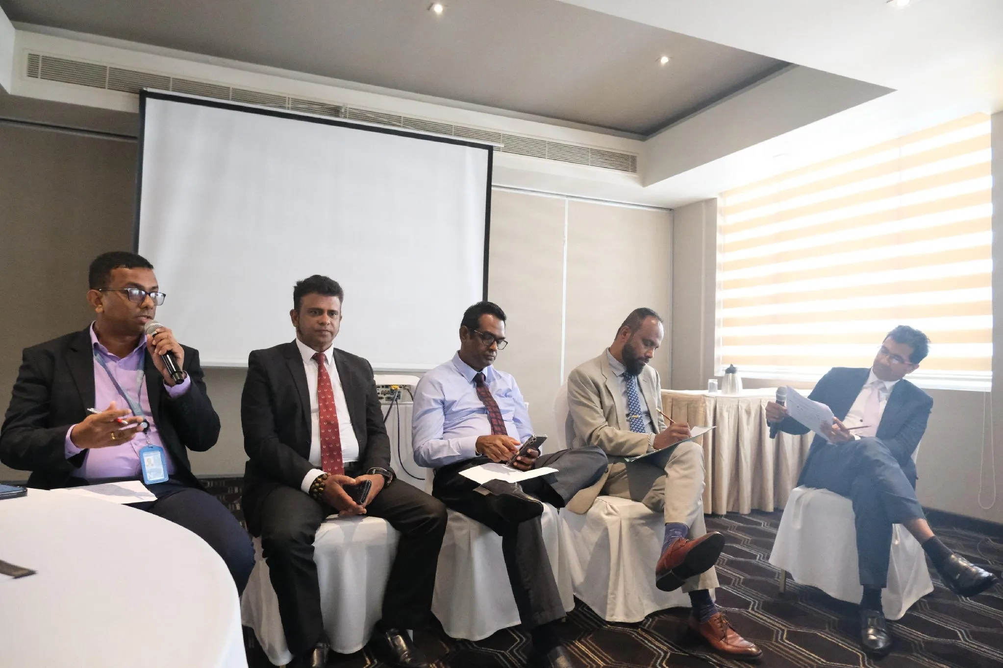
Workshop

Risk information is more useful when national experts can review the evidence, test the methods and connect the results with local planning needs.

During the workshop, technical experts examined the hazard data, analytical methods and findings to determine how well they represented Sri Lanka's coastal context.

National Validation Turned Evidence Into Action

  • National Validation of Risk Analytics
  • Improved Decision-Support Tools
  • Expanded Government Partnerships
  • Enhanced Capacity for Coastal Risk Planning
Department of Coast Conservation and Coastal Resource Management, Sri Lanka
Sri Lanka workshop photo 1

CS-018 · ClimaCoast Tool

Explore ClimaCoast tool

Multi-Hazard Vulnerability Coastal Tool — integrates tsunami, sea-level rise, storm surge, and other ocean-related hazards with exposure and vulnerability layers to pinpoint shoreline hotspots and guide actionable resilience planning.

Explore ClimaCoast
ClimaCoast v1.4 - Decision Support Sandbox

CS-019 · AI and Smart Solutions

Explore ClimaWise tool

AI-powered tool for climate adaptation planning with global case studies and tailored recommendations based on unique risk profiles.

Explore ClimaWise
ClimaWise AI Recommendation Portal

CS-020 · Impact-Based Forecasting

Impact-Based Forecasting

A new approach to understanding exposure to climate-induced events

Impact-Based Forecasting translates climate and weather information into practical, sector-relevant guidance: what will happen, who or what may be affected, and where early action may be most effective.

  • Helps answer not just what the weather will be, but what the weather will do, by combining hazard forecasts with information on exposure and vulnerability
  • Provides policymakers with a clear view of cascading risks across climate, disaster, environment and health domains
  • Delivers evidence-based analytics to support regional cooperation and actionable risk assessments
  • Translates technical hazard classifications into practical, localized insights for resilience building

Learn more about Impact-Based Forecasting

CS-021 · Support

Funded by

The Risk and Resilience Portal: Multi-Hazard Coastal Analysis and Adaptation project is funded by Climate Action for a Resilient Asia (CARA), the UK Government’s flagship climate adaptation programme.

Explore caraprogramme.org

CARA logo UK International Development logo

Our International Partners

INCOIS logo

Ocean information

Indian National Centre for Ocean Information Services

INCOIS →
RIMES logo

Early warning

Regional Integrated Multi-Hazard Early Warning System

RIMES →
SAHF logo

Regional coordination

South Asia Hydromet Forum

SAHF →
Met Office logo

Meteorological science

UK Met Office — Global Weather & Climate Services

Met Office →

CS-024 · Resources

Explore related resources

Explore related video, publications, technical resources and blogs for further insights into coastal risk and resilience.

Video
Documents
Publications
Blogs

Enlarged media

Please switch to Chrome or MS Edge to improve your experience.
UNESCAP Logo
© United Nations ESCAP

Additional Links

  • UN Website
  • UN Website locator
  • Privacy Notice
  • Terms of Use
  • Fraud Alert

Get social with us

Newsletter

Subscribe to our monthly email newsletter.