


CARA IBF Storyboard · ESCAP
From weather forecasts to early action
Impact-Based Forecasting translates climate and weather information into practical, sector-relevant guidance: what will happen, who may be affected, and what action can reduce loss.
Photo: Unsplash
Why It Matters
Impact Based Forecasting and Anticipatory Action
Between a credible forecast and the onset of a hazard lies a critical window of opportunity!
Impact-Based Forecasting transforms this window into action by translating weather forecasts into information on who and what is likely to be affected. This enables timely preparedness and anticipatory action.
WHY IT MATTERS?
Cascading risk visibility
Provides policymakers with a clear view of cascading risks across climate, disaster, and health domains.
Evidence-based analytics
Delivers evidence-based analytics to support regional cooperation and actionable risk assessments.
Risk-informed budgeting
Strengthens ministries' ability to plan and budget with risk-informed decision tools.
Localized insights
Translates technical hazard classifications into practical, localized insights for resilience building.
End Users
IBF answers the questions that actually save lives
At any given day, a weather forecast tells you that ‘50 mm of rainfall is expected’. An Impact-Based Forecast tells you what that 50 mm rainfall is likely to do to people, crops, infrastructure, and ecosystems, so action can be taken before impacts occur.
Setting Context
Moving from “what weather will be” to “what weather will do”
Between a credible forecast and the onset of a hazard lies a critical window of opportunity. Impact-Based Forecasting transforms this window into action by translating weather forecasts into information on who and what is likely to be affected, enabling timely preparedness and anticipatory action.
for communities (EW4ALL)
Click a card above to see how IBF supports it.
Global Development Agenda
How IBF supports global development agenda: Sendai Framework Targets
Substantially reduce global disaster mortality by 2030
Substantially reduce the number of people affected globally
Reduce direct disaster economic losses in relation to GDP
Reduce disaster damage to critical infrastructure and basic services disruptions
Substantially increase the availability of and access to multi-hazard early warning systems and disaster risk information
Communication Gap
Early warning works when expertise is connected
Despite advancements in climate modeling and forecasting, a major challenge remains in ensuring that climate information reaches the last mile — where it is needed most.
Impact-based forecasting acts as a bridge in translating scientific data into practical and timely risk information.
Source referenced in storyboard: Towards the “Perfect” Weather Warning: Bridging Disciplinary Gaps through Partnership and Communication.
Early Warnings for All
How IBF supports EW4ALL
Knowledge about risk is the first component of a successful early warning system (EWS). IBF supports Pillar 1 and Pillar 2 of the Early Warnings for All initiative and calls for all countries to have geo-referenced data platforms and tools to issue impact-based forecasting and warnings.
Disaster Risk Knowledge
Countries have data and tools to generate early warning products. Risk data is generated in a format adopted to early warning needs. Institutions have capacity to issue impact-based forecasts and warnings.

Observations, Monitoring, Analysis, Forecasting
Countries access global and regional forecasting products from GPCs, RSMCs, and NMHSs, national hydromet plans, strategies and legislation, and innovative forecasting products such as satellite data and applications.

Warning Dissemination and Communication
National ICT regulators promote and use CAP for national telecommunication companies. Warnings are issued in Common Alerting Protocol (CAP) format. NDMOs and NMHSs develop and apply people-centered standard operating procedures.

Preparedness and Response Capabilities
Preparedness and anticipation action plans are operational and linked to predictive and warning services. Risk maps, advisories and other warning products are available through ICT channels. Warning services are co-produced with organizations representing different gender, youth, older persons, people with disability, poor, marginalized and displaced people.
Global Framework for Climate Services
How IBF supports the Global Framework for Climate Services
IBF directly supports the GFCS's 5 priority areas:
- Agriculture & Food Security
- Disaster Risk Reduction
- Health
- Water
- Energy
Alignment with global priorities ensures that IBF is not just a tool for local preparedness, but contributes to broader climate resilience agendas.
Global Framework for Climate Services
Global Development Agenda
How IBF supports global development agenda: SDG
Select a Sustainable Development Goal to see how Impact-Based Forecasting contributes.


Data Inputs
What is needed for IBF assessment: integrating hazard, exposure and vulnerability
IBF turns a forecast into a risk picture by combining what could happen with what's in harm's way. Click each layer to see what sits inside it.
Flood, drought, coastal and seasonal hazards link to their assessment source; the rest are shown for reference.
Each layer opens its data source in a new tab.
Seasonal & Sub-Seasonal IBF
Why do seasonal and sub-seasonal IBF matter?
Climate policy tools
Finance, budgeting, adaptation process, NDC sector plans and budgeting.
Downscaled climate decision support systems
Inter-ministry coordination, anticipatory action, climate impact forecasting.
Targeted resilience building through seasonal impact forecasts for sectors
Example: what might happen to crops in this season?
Providing weekly warnings and guideline bulletins
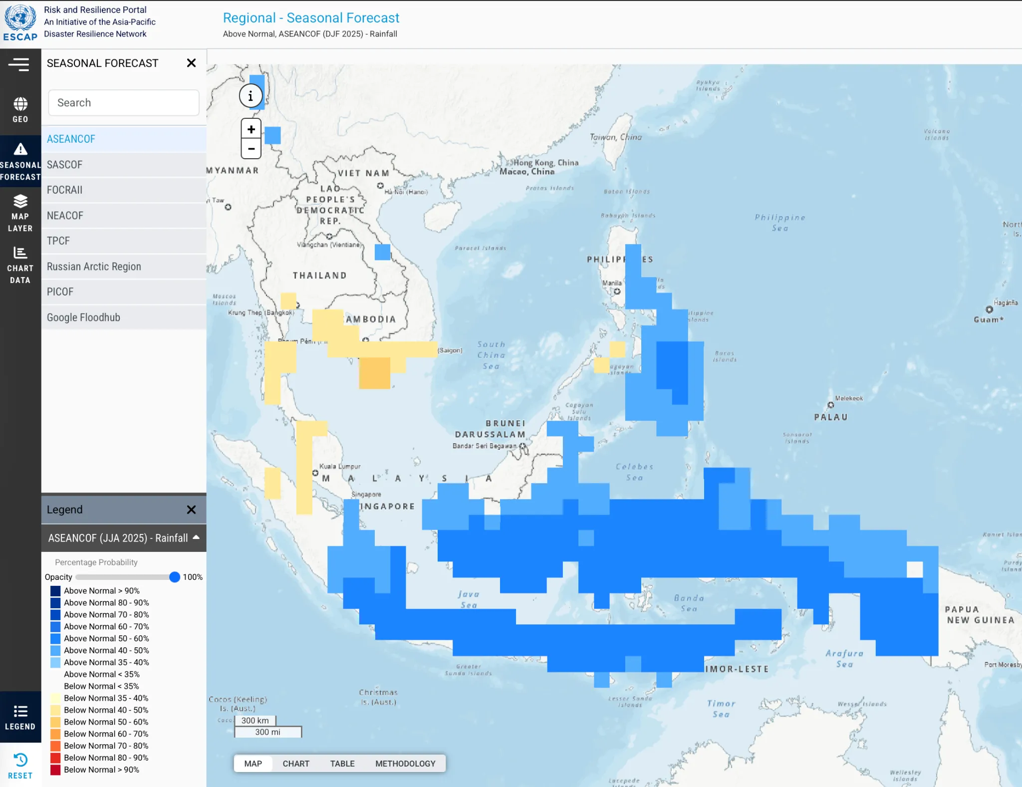
Seasonal Forecast Interpretation
How to Interpret Seasonal Weather Anomalies?
ESCAP IBF Tools
ESCAP's Tools: IBF-Next Plugin Offline Tool, Data Entry
ABOUT ESCAP IBF-Next Plugin: ESCAP IBF-Next is an offline QGIS plugin developed as a user-friendly tool to transform hazard data into actionable impact estimates. The plugin harmonizes hazard/ climate information with socio-economic exposure data and generates customized IBF reports and summary maps. Source: ESCAP IBF QGIS Plugin
How to use the plugin
Sample report generated from plugin
Regional Climate Outlook Forums
ESCAP Contributions to Regional Climate Forums
Select a forum to see the countries it connects to IBF.
IBF Case Studies
From Forecast to Action: IBF Case studies
The following cases demonstrate how ESCAP's Impact-Based Forecasting tools have been used across sectors and geographies to translate forecast information into actionable impact assessments and decision support.
Interpreting Climate Signals for Crops
Integrates seasonal climate forecasts, crop calendars, and crop production data to estimate the potential impact of rainfall and temperature anomalies on food production.
Tropical Cyclone Impact Assessment
Uses the ESCAP IBF Next QGIS Plugin to estimate exposure to forecast cyclone winds and generate impact-based reports.
Click a card above to see the full case study.
Agriculture IBF
Seasonal IBF helps interpret climate signals for crops
Agriculture IBF integrates seasonal forecasts with crop production data, crop calendars, growth stages, and literature-informed climate impact pathways to identify risk hotspots.
Collect forecasts
Gather seasonal temperature and precipitation anomaly information.
Reclassify likelihood
Classify data into low, moderate, and high likelihood categories.
Overlay crops
Combine forecast signals with crop production and crop calendar information.
Find hotspots
Identify places where climate signals align with sensitive crop stages.
IBF Next QGIS Plugin
Impact assessment of Tropical Cyclone Ditwah using the IBF tool
ESCAP IBF Next plugin allows users to track the impact of tropical cyclones on population, agriculture, and energy sectors. To conduct an IBF assessment using the tool, users can upload:
- Cyclone windspeed layer
- Population or agriculture exposure layer
- Administrative boundary shapefile
The plugin then generates customised impact reports and identifies the regions with severe impact.
Cyclone windspeed exposure layer
Generated impact assessment report
What Next
Where do we take IBF Next?
As climate risks become more complex, advancements in climate science, and impact modelling are needed to keep early warning systems effective.
The future of IBF lies in delivering people-centered warnings that answer not only what the weather will do, but “what will the weather do to me, my livelihood, and my community?”
Improve Methodology
Incorporate multi-hazard and vulnerability elements — e.g. coral bleaching IBF.
Convert operational weather data
Convert operational weather forecast data from weather stations into a GIS-compatible format for better integration into IBF workflows.
Localization
Deliver impact-based warnings in local languages, supported by hyperlocal exposure information and context-specific action workflows.
Communication and dissemination
Support countries in their IBF workflows. Based on IBF results, customize communication and warning messages for different ministries/agencies and local governments for their actions, including for bulletin purposes.